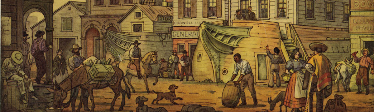
Very Important Passengers
William Eddy
Surveyor General of California; 1819 (New York) to 1854 (San Francisco)
In 1851, residence was noted as 208 Herron.
Jasper O'Farrell, during his term as City Surveyor, had extended the streets originally laid down by a man named Jean Jacques Voget in 1839. O'Farrell extended streets into the Bay; designed the grand promenade that is Market Street, partly to resolve the conflicting grids in the northern and southern parts of the City; and prepared for the sale of water lots on the still submerged streets as early as July 1847, but his maps do not include Davis, Front and Drumm streets.
O'Farrell left the job at the beginning of the Gold Rush, and in August of 1849; the position of City Surveyor was given to William M. Eddy.
Two different men named William Eddy arrived five months apart. The second Eddy was a representative of an investment group from New York who went on to become a banker and died in Santa Barbara. William M. Eddy, the surveyor, was born in New York in 1819: arrived on the U.S. Mail Steamship Oregon on June 13, 1849.
While Surveyor of San Francisco, William Eddy office was in a corrugated iron building at the northeast corner of Dupont and Clay Street, owned and built by Edward Laffan, and called the Laffan Building. There he headed a crew including J. P. Bush, a helper, and Nib Hoadley, engineer.
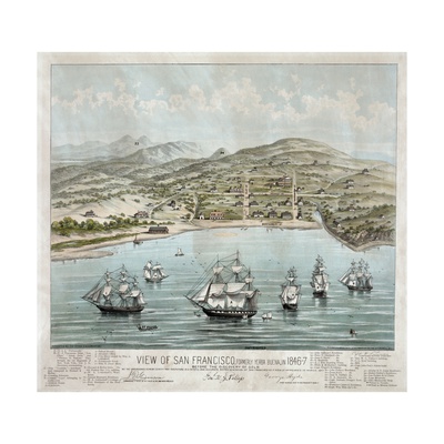
Yerba Buena Cove
(San Francisco)Hoadley's diary at the Bancroft Library includes critiques of that Sunday's sermons; exact accounting of expenditures, number of drinks consumed, medication, including opium, for a sick friend; surveys -- "Courses by needle" -- South of Market, April 1849, "Coast of Yerba Buena Cove" "Mission Creek" a measurement to Mt. Diablo (27-1/2 miles) and notes relating to various jobs beginning in March 1837 and including plans for the first water system and later "rail roads."
During his employment with Eddy, Hoadley's entries include: "Mar. 11, '50 . . . established points with Mr. Eddy as finally fixed and corrected line westward to Stockton disagreeing with his work on Stockton from 10-18 inches. Went to office 2d time P.M. to report and found him drunker than usual." And "A modest man cannot run for office. B ofs E. certainly cannot be accused of that. I have some suspicion that he played me foul in the matter but think I have him on the hip. Haven't been in his office 4 months for 'nothing. He is an old campaigner up to all the tricks of New York politicians and entirely destitute of principle."
The Bancroft Library (Berkeley, California), has a copy of the maps "Presented to the Senators and Representatives from California by Wm. K. Eddy, City Surveyor of San Francisco, December 31, 1849."
On that map, "Drumm Street" first appears and is spelled with one "M". (Map makers traditionally include an error in their work to see if someone is copying their maps. The error most commonly used is the name of a street that does not yet exist.)
|
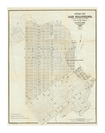
That map was accepted and applauded by the City Council Jan. 28, 1850. There was an earlier map that was rushed off to Oregon city for copyright, but it does not include Davis; Front and Drumm Streets.
On a "First official" map dated Jan. 15, 1851, Drumm street first appears as we know it today. All subsequent maps up to the present maintain that spelling.
Daily Alta California, September 5, 1851
Election Returns
We published yesterday morning the full returns from the Eighth District, and the county precincts. Below is a continuation of the returns, as they have come in, in the various wards, most of them still incomplete. The manner of counting the votes, is so slow a one, and the tickets are so scratched, that it will require till to-morrow to finish. The vote on the Charter ticket we have not given, as there was no opposition, and the whole Democratic ticket is of course elected. (William Eddy ran in this election in the Third District for Surveyor General on the Democratic Ticket.)
Daily Alta California, March 27, 1852
THE WATER LOT BOUNDARY
The Charges of Fraud Against the Enrolling Clerk Proved to be False.
MESSRS. EDITORS:-- I have read in the recent published proceedings of the Legislature, reporter's statements and legislative speeches on the subject of an alleged discrepancy between the first water lot bill as it passed the Legislature, and the bill as it afterwards came from the hands of the enrolling clerk. In those remarks the clerk is charged with having been induced to make alterations in the bill after its passage. I do not know who the enrolling clerk was, but I do know that he is innocent of any such offence. I myself made the alterations referred to, but they were made as amendments to the bill, and were made some time beforeit had passed. Mr. Eddy, the City Surveyor, had sent down to San Jose maps of the City of San Francisco, and a written description of the outside water front, neither of which deviated from the old plan of the city, with the exception of an addition of water property at the mouth of Mission Creek. The description was lengthy, occupying a full page or more of the printed bills, and I do not suppose that a single member of either house took the pains to trace it out on the map to see how the one compared with the other.

Being there at that time in the employ of the city, to give such statistical information and to make such suggestions to members of the Legislature as might be desirable in the framing of the bill, and the subject being one with which I was most familiar, various members handed the bill to me to suggest such amendments amendments and alterations as I thought proper; as they did likewise to other gentlemen who represented other interests. I made various amendments, and also took the map and description sent down by the Surveyor, and compared the two. I found that in several places, as for instance, at Rincon and Clark's points, the water front line on the map came so near the shore that the insertion of an additional block could be made without detriment to commerce, and be so much gain to the city. Also, that the water line on the north side of Central Wharf did not extend so far out into the bay by a whole block as it did on the south side, and that a block there would be worth to the city fifty thousand dollars. And again, that in the angles formed by the water line in the neighborhood of Pacific street and Broadway, one or two additional blocks might be laid out. I therefore drew on the map the water front line, with these alterations, and amended the description in the bill to make it conform, and returned the bill to those from whom I had received it.
The bill, with these amendments, was then printed; and each bill subsequently printed (and there were many before the bill finally passed,) contained the same description of boundaries. I made no particular mention, that I now recollect, of this alteration of boundary, as I deemed it of but little importance to the Legislature, the main question to them being on the merits of the bill. Neither had I any knowledge or suspicion that any individual or individuals laid claim to any portion of the blocks added to the map by me, with the exception of the one on which a vessel had been sunk at the end of Central Wharf. And as there was no record of any pretended grant even of that block at the time I made my Report on the subject of Land Titles, and as Colton grantees received no benefit whatever from the bill, I presumed that the city would put the whole benefit of my alterations in the boundary line, as she would have done, had not the "Colton Grant Act" been subsequently passed, and as she yet may do, if the present Legislature will but have the virtue to repeal that latter act.
I should have made this statement earlier, but have just returned to the city after an absence of nearly a month, and only yesterday read the proceedings of the Legislature, by which my attention was directed tot he matter. Yours respectfully,
ALFRED WHEELER
San Francisco, March 24, 1852
May 29, 1852, Daily Alta California, San Francisco, California
BOUNDARY LINE AT CARSON Valleys. -- We learn that Mr. William M. Eddy, our State Surveyor General, has completed his arrangements for determining the location of the boundary line of our State where it runs through Carson Valley, on the East Side of the Sierra Nevada. Population is gradually increasing in that fertile spot, and it is highly necessary that it should be determined which portion should take part in the affairs of California, and which in the affairs of Utah. We understand that it is in contemplation to create a new county in that section of California. Mr. Eddy leaves with the train to be sent out by the State for the relief of the overland emigrants.
July 3, 1852, Daily Alta California, San Francisco
Surveyor General Eddy and party arrived in this place on Wednesday, where they have been engaged in taking astronomical observations. They go from here to Carson Valley, for the purpose of determining the eastern boundary line of this State, and to ascertain whether Carson Valley belongs to this State or to Utah--El Dorado News

The Annals of San Francisco
1855. Frank Soule, John H. Gihon, James Nisbet
Written by three journalists who were witnesses to and participants in the extraordinary events they describe. The Annals of San Francisco is both an essential record for historians and a fascinating narrative for general readers. Over 100 historical engravings are included. Partial Contents: Expeditions of Viscaino; Conduct of the Fathers towards the natives; Pious Fund of California; Colonel John C. Fremont; Insurrection of the Californians; Description of the Golden Gate; The Mission and Presidio of San Francisco; Removal of the Hudson's Bay Company; Resolutions concerning gambling; General Effects of the Gold Discoveries; Third Great Fire; Immigration diminished; The Chinese in California; Clipper Ships; Increase of population; and Commercial depression.

The Naval Order of the United States has a history dating from 1890. Membership includes a wide range of individuals, many with highly distinguished career paths. When it was established, the Founders provided "that any male person above the age of eighteen years who either served himself, was still presently serving, or was descended from an officer or enlisted man who served in any of the wars which the U.S. Navy, Marine Corps, or Revenue or Privateer services was engaged was eligible for Regular membership." Today, the Order is a "by invitation only" society, and includes men and women who have served or who assist in accomplishing its Mission, including research and writing on naval and maritime subjects.
The San Francisco Commandery meets the first Monday of each month in San Francisco, California and holds two formal dinners each year:
