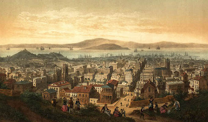
Sea Captains: San Francisco 1800s
Samuel Leach
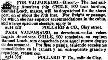
February 8, 1849, Weekly Alta California, San Francisco
Marine Journal: Arrived: February 6th, American Ship Chile, Leach, master, sailed from New York, August 5th and Valparaiso December 14th, with government stores.
By the arrival at this port of the American ship Chile, we have received files of American papers up to August 5, 1848. Of course, she brings no late intelligence, but such paragraphs as we can find of general interest will be published in our next number.
The Chile, Leach, master, sailed from New York on the 5th August, laden with stores and property for the Pacific squadron. She touched at Valparaiso on her passage, leaving that port for California on the 14th of December. On arriving on this coast, she put it at Monterey, remaining there two days. From that port she came here, arriving on Tuesday morning last. Contrary to expectation she brings a small mail and a few passengers. We are informed that the cargo will be unladen here, and that one of its articles is a steam saw and grist mill, for the use of the Navy.
We learn verbally by the Chile that the steamer California had not arrived at Valparaiso, though she as daily expected. Another account says that the steamer would nto touch at Valparaiso, but would stoip at Callao to refit, and letters received by the Ann McKim say that she was daily expected at the Port. It is difficult to decide, from these conflicting accounts, at what time the first steamer will be likely to reach San Francsico, but we think she will certainly arrivefd by the first of March.

In several of the August papers, printed in the city of New York we observe California correspondence. The authors represent the country as possessing unheard of mineral wealth, but mention nothing of gold mines. Silver, quicksilver, lead and iron, are spoken of, and one author says that California will undoubtedly owe a great share of her future prosperity to her quicksilver mines. Long ere this, we presume, the news of the gold discovery will have produced as great a revolution in the United States in regard to these subjects, as have already taken place in California itself.
February 8, 1849, Weekly Alta California, San Francsico
FROM CHILE.
By the American ship Chile we have dates from Valparaiso to the 13th of December, 1848. The excitement relative to the gold mines in this country is still very great. Merchandise of all kinds is in great demand, and as fast as it arrives is reshipped to this port. In addition to the vessels heretofore announced for California, we find in El Mercurio of December 13, 1848, the Chilian brig J. R. S., brigantine Rayo, schooner Calavera, ship Julia, and schooner Lambayocana. All these vessels, as well as the six before advertised, will bring passengers and merchandise. — It is said that one of the vessels will bring a cargo of houses complete and ready for erection.
July 2, 1849, Weekly Alta California, San Francisco, California
List of vessels at Saucelito. March, Amercan Ship Chile, Leach, Valparaiso.
August 16, 1849 and August 23, 1849, Daily Alta California, San Francisco
April 12, 1850, Daily Alta California, San Francisco: Cleared American bark Laura, Captain Leach, Ports in Chile.
November 4, 1850, Sacramento Transcript, Sacramento, California
Marine Intelligence. Port of San Francisco.
Arrived October 31, 1850 Bark Laura, Leach. 82 days from Valparaiso.
March 22, 1851, Sacramento Daily Union, Sacramento, California
Marine News, Port of San Franccisco
Arrived March 29, Ship Chile, Leach, 240 days from Boston via Valparaiso, 72 days. Mdse to Hussey, Bond & Hale.
August 16, 1851, Sacramento Daily Union, Sacramento
August 13, Ship Chile, Leach, cleared for Calcutta. Hussey, Bond & Hale.
The Sea Chart
The Illustrated History of Nautical Maps and Navigational Charts
John Blake
The sea chart was one of the key tools by which ships of trade, transport and conquest navigated their course across the oceans. John Blake looks at the history and development of the chart and the related nautical map, in both scientific and aesthetic terms, as a means of safe and accurate seaborne navigation. This handsome work contains 150 color illustrations including the earliest charts of the Mediterranean made by thirteenth-century Italian merchant adventurers, as well as eighteenth-century charts that became strategic naval and commercial requirements and led to Cook's voyages in the Pacific, the search for the Northwest Passage, and races to the Arctic and Antarctic.

The Authority to Sail: The History of U.S. Maritime Licenses and Seamen's Papers
Robert Stanley Bates, George Marsh (Editor), John F. Whiteley (Forward) (Batek Marine Publishing, 2011; Nominated in 2012 for a Pulitzer Prize)
This book depicts important aspects of our maritime history as a result of original research done by the author, Commodore Bates, the holder of an unlimited master's license who has enjoyed a distinguished fifty-year career in both the Coast Guard and the American Merchant Marine.
The U.S. Coast Guard issues all Captain Licenses for U.S. Ports.
Note: Other countries have different regulations, i.e. the RYA (Royal Yachting Association), conducts certification for Britain and Ireland. As of 2011, they did not recognize the USCG certification; certification through their courses was required.Master Unlimited is a licensed mariner in ultimate command of a vessel any gross tons. The captain is responsible for its safe and efficient operation, including cargo operations, navigation, crew management and ensuring that the vessel complies with local and international laws. All persons on board, including officers and crew, other shipboard staff members, passengers, guests and pilots, are under the captain's authority and are his or her ultimate responsibility. The STCW defines the Master as Person having command of the ship.
The Sea Chart
The Illustrated History of Nautical Maps and Navigational Charts
John Blake
The sea chart was one of the key tools by which ships of trade, transport and conquest navigated their course across the oceans. Herein is a history and development of the chart and the related nautical map, in both scientific and aesthetic terms, as a means of safe and accurate seaborne navigation. 150 color illustrations including the earliest charts of the Mediterranean made by 13th-century Italian merchant adventurers, as well as 18th-century charts that became strategic naval and commercial requirements and led to Cook's voyages in the Pacific, the search for the Northwest Passage, and races to the Arctic and Antarctic.
Get Your Captain's License. Fifth Edition
Charlie Wing
Considered the quickest, easiest, and least expensive way to prepare for the U.S. Coast Guard captain's ratings exams required for anyone who takes paying passengers on a boat, and useful for serious boaters who want to save money on insurance. 350 pages of seamanship and navigation tutorials. More than 1,500 questions and answers from the Coast Guard exams. Includes an interactive CD-ROM with all 14,000 questions and answers in the USCG database, so you can take an unlimited number of practice exams

Site Search

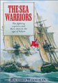
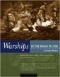
Warships of the World to 1900
Lincoln P. Paine.

True Yankees: The South Seas and the Discovery of American Identity
(Johns Hopkins University Studies in Historical and Political Science)
Dane A. Morrison
Stephan Talty
Navigation Rules and Regulations Handbook
U.S. Coast Guard
The Navigation Rules & Regulations Handbook supersedes Commandant Instruction M16672.2D This edition includes LNM 39-15 and NTM 41-15 33 CFR 83.01(g) requires: "The operator of each self-propelled vessel 12 meters or more in length shall carry, on board and maintain for ready reference, a copy of these Rules."

American Merchant Ships
1850-1900
Frederick C. Matthews