Sea Captains: San Francisco 1800s
William Henry Percy Hains
January 1, 1852, Daily Alta California, San Francisco, California, U.S.A.
Marine Journal
Port San Francisco, December 30, 1851
Cleared
Barque Laila Rookh (Br), Haines, Tahiti and Sydney; Hort Bros.
September 14, 1852, Daily Alta California, San Francisco, California, U.S.A.
Shipping Intelligence
Port of San Francisco, September 14, 1852
SPOKEN
Per Ceylon, August 29th, lat 37 53, long 145 W., British barque Laila Rookh, Haines, from Sydney, for this port, who kindly suppled the Ceylon with provisions.
October 29, 1852, Daily Alta California
Shipping Intelligence
November 6, 1852, Daily Alta California
San Francisco, California, U.S.A.
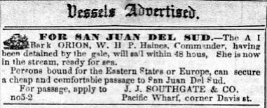
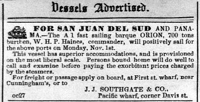
October 11, 1853, Daily Alta California
San Francisco, California, U.S.A.
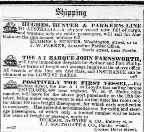
October 22, 1853, Daily Alta California, San Francisco, California
Shipping Intelligence
Port San Francisco, October 22, 1853
Cleared: October 21: Br. barque Envelope, Hames (cq: misspelling), Sydney, Dickson, DeWolf & Co.
June 24, 1854, Daily Alta California, San Francisco, California
Shipping Intelligence
Port of San Francisco, June 24, 1854
Arrived
Br. barque Envelope, Haines, from New Castle, N.S.W., March 14th with coal; to Dickson, DeWolfe & Co. Anchored off North Beach.
June 24, 1854, Daily Alta California, San Francisco, California
Disaster.
Barque Envelope, March 24th, when 600 miles north of New Zealand, in a sudden shift of wind, carried away her bowsprit, foretopmast and foremasthead under the rigging; they were lost with everything attached -- mainsail, maintop-sail, maintop-gallantmast and yard. Has been ten days without foretopsail; has sailed from thence under jury masts. Had very light S.E. Trades. Made the best half of the passage under jury masts.
On July 14, 1854, the Daily Alta California reported that the 423 tons Sydney Coal, ex Envelope, for sale on private terms.
 Relief Map of San Francisco Bay Area showing the entrance through the Golden Gate. |
The Sea Chart
The Illustrated History of Nautical Maps and Navigational ChartsJohn Blake
The sea chart was one of the key tools by which ships of trade, transport and conquest navigated their course across the oceans. John Blake looks at the history and development of the chart and the related nautical map, in both scientific and aesthetic terms, as a means of safe and accurate seaborne navigation. This handsome work contains 150 color illustrations including the earliest charts of the Mediterranean made by thirteenth-century Italian merchant adventurers, as well as eighteenth-century charts that became strategic naval and commercial requirements and led to Cook's voyages in the Pacific, the search for the Northwest Passage, and races to the Arctic and Antarctic.

The Authority to Sail: The History of U.S. Maritime Licenses and Seamen's Papers
Robert Stanley Bates, George Marsh (Editor), John F. Whiteley (Forward) (Batek Marine Publishing, 2011; Nominated in 2012 for a Pulitzer Prize)
This book depicts important aspects of our maritime history as a result of original research done by the author, Commodore Bates, the holder of an unlimited master's license who has enjoyed a distinguished fifty-year career in both the Coast Guard and the American Merchant Marine.
The U.S. Coast Guard issues all Captain Licenses for U.S. Ports.
Note: Other countries have different regulations, i.e. the RYA (Royal Yachting Association), conducts certification for Britain and Ireland. As of 2011, they did not recognize the USCG certification; certification through their courses was required.Master Unlimited is a licensed mariner in ultimate command of a vessel any gross tons. The captain is responsible for its safe and efficient operation, including cargo operations, navigation, crew management and ensuring that the vessel complies with local and international laws. All persons on board, including officers and crew, other shipboard staff members, passengers, guests and pilots, are under the captain's authority and are his or her ultimate responsibility. The STCW defines the Master as Person having command of the ship.
The Sea Chart
The Illustrated History of Nautical Maps and Navigational Charts
John Blake
The sea chart was one of the key tools by which ships of trade, transport and conquest navigated their course across the oceans. Herein is a history and development of the chart and the related nautical map, in both scientific and aesthetic terms, as a means of safe and accurate seaborne navigation. 150 color illustrations including the earliest charts of the Mediterranean made by 13th-century Italian merchant adventurers, as well as 18th-century charts that became strategic naval and commercial requirements and led to Cook's voyages in the Pacific, the search for the Northwest Passage, and races to the Arctic and Antarctic.
Get Your Captain's License. Fifth Edition
Charlie Wing
Considered the quickest, easiest, and least expensive way to prepare for the U.S. Coast Guard captain's ratings exams required for anyone who takes paying passengers on a boat, and useful for serious boaters who want to save money on insurance. 350 pages of seamanship and navigation tutorials. More than 1,500 questions and answers from the Coast Guard exams. Includes an interactive CD-ROM with all 14,000 questions and answers in the USCG database, so you can take an unlimited number of practice exams

Site Search

Great Stories of the Sea & Ships
N. C. Wyeth
High-seas adventures showcasing the fiction of classic writers as Daniel Defoe, Jules Verne, and Jack London, but also historic first-person narratives. Tales of heroic naval battles, dangerous journeys, stories of castaways and smugglers, including The Raft of Odysseus, by Homer; Hans Christian Andersen's The Mermaid, Rounding Cape Horn, by Herman Melville.
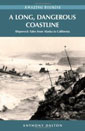
Shipwrecks of the California Coast: Wood to Iron, Sail to Steam
Michael D. White


American Merchant Ships
1850-1900
Frederick C. Matthews